 Globetto
All 50 US states
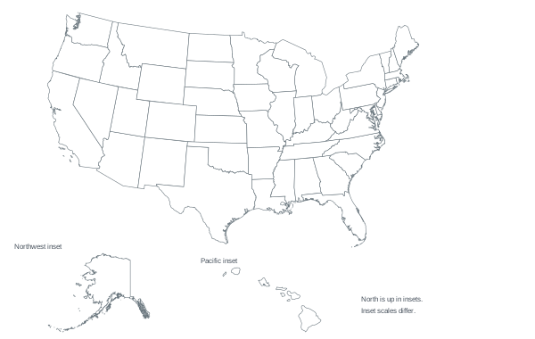
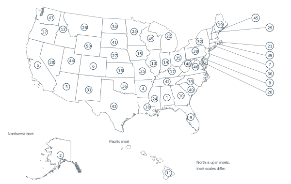
A blank map, a numbered practice map and a separate key, including Alaska and Hawaii.
Try these places in a quiz
Practice the 50-state set →What is included
Exactly 50 states are included. Washington, DC is a federal district, not a state; it and US territories are excluded. Alaska and Hawaii appear in separate insets, at different scales from the mainland.
The numbered map uses alphabetical state order. The separate key pairs every number with its state name and postal abbreviation.
Sources: State codes - US Census Bureau; Natural Earth vector data.
Three classroom activities
- Blank-map recall: label as many states as you can in three minutes, then use an atlas to finish in a second color or with a star beside added names.
- Number partners: one person picks five map numbers; the other names those states. Swap roles, then check the key.
- Neighbor chain: choose any mainland state and name three states connected by shared borders. Explain each step using the map; this is an open-ended task, so several chains work.
Text alternative
If a visual map is not useful, expand the 50 postal abbreviations below into full state names. This is a different recall task using the same 50-state set. The answers are on the separate key.
The online round samples ten questions from all 50 states.
Practice questions
Practice
1. Name state 1 on the numbered map. Text alternative: expand AL.
2. Name state 2 on the numbered map. Text alternative: expand AK.
3. Name state 3 on the numbered map. Text alternative: expand AZ.
4. Name state 4 on the numbered map. Text alternative: expand AR.
5. Name state 5 on the numbered map. Text alternative: expand CA.
6. Name state 6 on the numbered map. Text alternative: expand CO.
7. Name state 7 on the numbered map. Text alternative: expand CT.
8. Name state 8 on the numbered map. Text alternative: expand DE.
9. Name state 9 on the numbered map. Text alternative: expand FL.
10. Name state 10 on the numbered map. Text alternative: expand GA.
11. Name state 11 on the numbered map. Text alternative: expand HI.
12. Name state 12 on the numbered map. Text alternative: expand ID.
13. Name state 13 on the numbered map. Text alternative: expand IL.
14. Name state 14 on the numbered map. Text alternative: expand IN.
15. Name state 15 on the numbered map. Text alternative: expand IA.
16. Name state 16 on the numbered map. Text alternative: expand KS.
17. Name state 17 on the numbered map. Text alternative: expand KY.
18. Name state 18 on the numbered map. Text alternative: expand LA.
19. Name state 19 on the numbered map. Text alternative: expand ME.
20. Name state 20 on the numbered map. Text alternative: expand MD.
21. Name state 21 on the numbered map. Text alternative: expand MA.
22. Name state 22 on the numbered map. Text alternative: expand MI.
23. Name state 23 on the numbered map. Text alternative: expand MN.
24. Name state 24 on the numbered map. Text alternative: expand MS.
25. Name state 25 on the numbered map. Text alternative: expand MO.
26. Name state 26 on the numbered map. Text alternative: expand MT.
27. Name state 27 on the numbered map. Text alternative: expand NE.
28. Name state 28 on the numbered map. Text alternative: expand NV.
29. Name state 29 on the numbered map. Text alternative: expand NH.
30. Name state 30 on the numbered map. Text alternative: expand NJ.
31. Name state 31 on the numbered map. Text alternative: expand NM.
32. Name state 32 on the numbered map. Text alternative: expand NY.
33. Name state 33 on the numbered map. Text alternative: expand NC.
34. Name state 34 on the numbered map. Text alternative: expand ND.
35. Name state 35 on the numbered map. Text alternative: expand OH.
36. Name state 36 on the numbered map. Text alternative: expand OK.
37. Name state 37 on the numbered map. Text alternative: expand OR.
38. Name state 38 on the numbered map. Text alternative: expand PA.
39. Name state 39 on the numbered map. Text alternative: expand RI.
40. Name state 40 on the numbered map. Text alternative: expand SC.
41. Name state 41 on the numbered map. Text alternative: expand SD.
42. Name state 42 on the numbered map. Text alternative: expand TN.
43. Name state 43 on the numbered map. Text alternative: expand TX.
44. Name state 44 on the numbered map. Text alternative: expand UT.
45. Name state 45 on the numbered map. Text alternative: expand VT.
46. Name state 46 on the numbered map. Text alternative: expand VA.
47. Name state 47 on the numbered map. Text alternative: expand WA.
48. Name state 48 on the numbered map. Text alternative: expand WV.
49. Name state 49 on the numbered map. Text alternative: expand WI.
50. Name state 50 on the numbered map. Text alternative: expand WY.
Print the student worksheet
Sources and reuse
You may print and share these worksheets for teaching or personal practice. Keep the source and version notes with copies. GeoNames facts remain under CC BY 4.0; Natural Earth boundaries are public domain. No backlink is required.
- State codes - US Census Bureau — State names and codes; DC is separately listed and explicitly excluded from this 50-state scope. Checked 2026-10-20.
- Natural Earth vector data — Country and state boundary context; not a statement on disputed sovereignty. Checked 2026-10-20.
- Natural Earth terms of use — Public-domain map data, including modified electronic and printed maps. Checked 2026-10-20.
Prepared and source-checked by Codex AI. No human classroom review or translated-language review is claimed. Revision 1; answer key 1. Updated 2026-10-20.
PDFs are not tagged for assistive reading. This HTML page provides the same instructions, questions and text alternatives.